
-
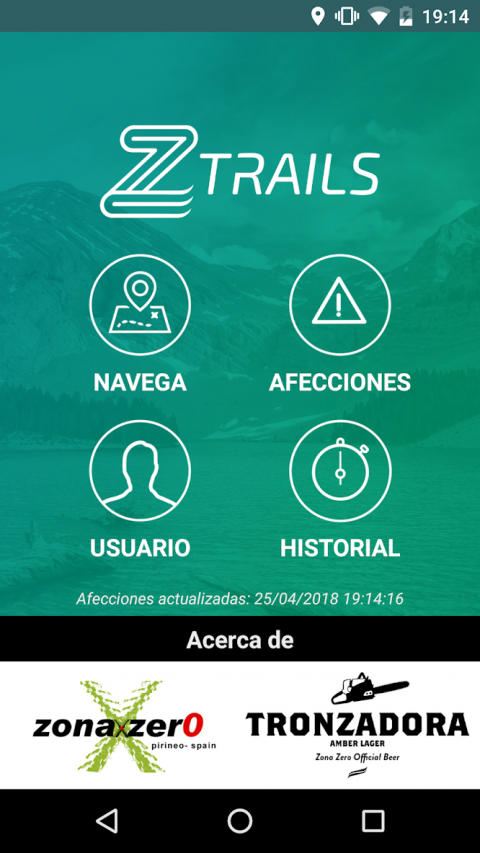
ZTrails
Latest Version: Publish Date: Developer: 1.1.1 2021-03-20 GeoSLab
The description of ZTrails
ZTrails offers a wide catalog of routes in continuous growth, informs of the state of the trails and facilitates the coexistence of the different users of the mountain.
ZTrails warns of the hunting scheduled in the area and other incidents that affect the routes such as landslides, flooding of rivers, closures due to overexploitation of a path, sports races, snow or other conditions.
MAIN FEATURES
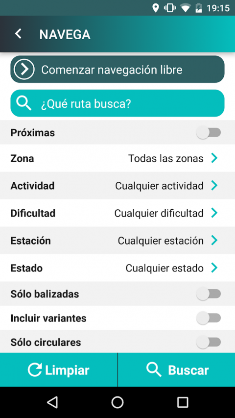
- Search engine for routes, allowing you to filter the search by name, nearby routes, zone, activity, difficulty, recommended season, status, distance, time, elevation gain, distance by path, routes marked, variants, circulars, etc.
- List of routes, showing their status (opened without events, affected or closed).
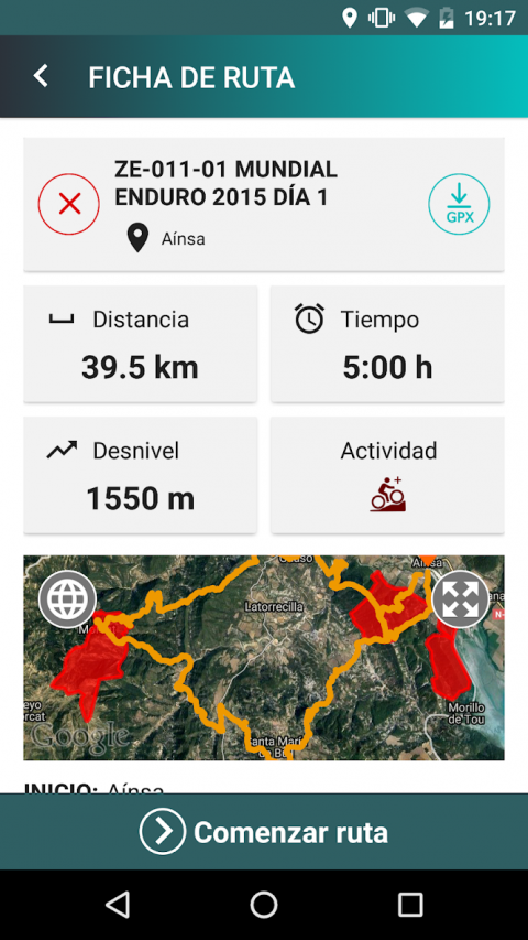
- Access to detailed information about the route, including visualization of the route on the map and access to multimedia information (profile, general map, photographs).
- Tracking of a specific route or free navigation, keeping you informed of your position with respect to scheduled hunting beats (warnings when approaching or entering a hunting beat).
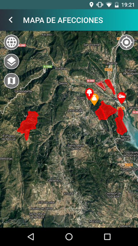
- Incidents map that shows the different types of events that have been registered, and their status (beginning, ending, description, photographs).
- History of routes made by the user, classified by activity type, history of conditions and comments made by the user.
- Access to detail of routes made at the user history, showing associated profile and altitude data.
- Update routes and conditions when entering the application, to have the last-minute changes on your mobile.
REMEMBER:
- Your safety is the most important, do not put yourself in danger.
- Respect the rest of the users of the mountain and traditional activities.
- Do not throw garbage or get out of the way.
- If you go by bike and you meet with hikers, stop, say hello and let them pass.
- In hunting season pay attention and respect the signage choosing alternative routes.
- Remember that to receive notifications you have to be following a route or have started free navigation.
ABOUT US
ZTrails arises from the collaboration between the Zona Zero Business Association and the Cerveza Rondadora company, with the aim of contributing to the sustainable growth of the region's economic development and improving the coexistence of all mountain users.
This project could not have been carried out without the collaboration of the town councils, the Sobrarbe region and the hunting associations of the territory that have lent their trust, their help and knowledge throughout the project.
This project has been carried out under the Local Development Strategy Leader 2014-2020, managed by the Center for the Development of Sobrarbe and the Ribagorza (CEDESOR) and financed by the European Fund EAFRD and the Government of Aragon.
All the information published in ZTrails, and, specifically, the information of the hunting hunts, is what the different preserves and users provide to ZONA ZERO. ZONA ZERO will verify, within its capabilities, such information, without being responsible for the consequences derived from the use of this information.
ZTrails warns of the hunting scheduled in the area and other incidents that affect the routes such as landslides, flooding of rivers, closures due to overexploitation of a path, sports races, snow or other conditions.
MAIN FEATURES
- Search engine for routes, allowing you to filter the search by name, nearby routes, zone, activity, difficulty, recommended season, status, distance, time, elevation gain, distance by path, routes marked, variants, circulars, etc.
- List of routes, showing their status (opened without events, affected or closed).
- Access to detailed information about the route, including visualization of the route on the map and access to multimedia information (profile, general map, photographs).
- Tracking of a specific route or free navigation, keeping you informed of your position with respect to scheduled hunting beats (warnings when approaching or entering a hunting beat).
- Incidents map that shows the different types of events that have been registered, and their status (beginning, ending, description, photographs).
- History of routes made by the user, classified by activity type, history of conditions and comments made by the user.
- Access to detail of routes made at the user history, showing associated profile and altitude data.
- Update routes and conditions when entering the application, to have the last-minute changes on your mobile.
REMEMBER:
- Your safety is the most important, do not put yourself in danger.
- Respect the rest of the users of the mountain and traditional activities.
- Do not throw garbage or get out of the way.
- If you go by bike and you meet with hikers, stop, say hello and let them pass.
- In hunting season pay attention and respect the signage choosing alternative routes.
- Remember that to receive notifications you have to be following a route or have started free navigation.
ABOUT US
ZTrails arises from the collaboration between the Zona Zero Business Association and the Cerveza Rondadora company, with the aim of contributing to the sustainable growth of the region's economic development and improving the coexistence of all mountain users.
This project could not have been carried out without the collaboration of the town councils, the Sobrarbe region and the hunting associations of the territory that have lent their trust, their help and knowledge throughout the project.
This project has been carried out under the Local Development Strategy Leader 2014-2020, managed by the Center for the Development of Sobrarbe and the Ribagorza (CEDESOR) and financed by the European Fund EAFRD and the Government of Aragon.
All the information published in ZTrails, and, specifically, the information of the hunting hunts, is what the different preserves and users provide to ZONA ZERO. ZONA ZERO will verify, within its capabilities, such information, without being responsible for the consequences derived from the use of this information.
What's new of ZTrails
What's new:
· GPS location management adjustments to improve the user experience in route tracking and free navigation
· Minor bug fixes
· GPS location management adjustments to improve the user experience in route tracking and free navigation
· Minor bug fixes
| Category: | Requirements: |
|---|---|
| Maps & Navigation | Android 4.0+ |
Related Apps for ZTrails android
-

-
ZTrails
2021-03-20


